5 of the Best Cape York 4WD Tracks

 Image courtesy of Tourism Cape York
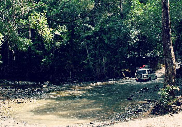
Cape York is 4WD Only!
The rugged nature of the wilderness means Cape York should only be tackled with a 4WD. It’s wild country up there so you’ll need high clearance and low range gears to get through. Take traction and recovery equipment with you and, ideally, travel with another vehicle. Your vehicle needs to be in peak mechanical condition with robust walled tyres to survive the difficult terrain. If your vehicle doesn’t already have one, invest in a snorkel to get through the deep creek crossings. A bull bar is also a worthy addition to protect you from collisions with wild animals. As towing isn’t possible, you will need to carry all of your gear on the vehicle - invest in a cargo barrier so you can pack the back to the hilt and not be concerned about passenger safety when you are taking on rugged sections of the track.Cape York 4WD Trip Planner
There is plenty to see and do around Cape York, so you need to be organised if your touring time is limited. Know in advance which tracks you are going to do and how long you expect it to take. Make an itinerary listing the places you want to stop and things you want to see along the way. You don’t want to miss anything. Make a note of the kilometres between each stop and adjust the itinerary if you find you are doing more or fewer kilometres each day. Share a copy of the plan with a family member back home particularly if you aren’t travelling with another vehicle.Best Time to Travel to Cape York
When visiting Cape York, you need to take the wet and dry seasons into consideration. The best time to travel to Cape York is between May and October, which is the dry season. This will ensure access to the best 4WD tracks and avoid wet season flooding.5 of the Best Cape York Tracks
We have put together an overview of five of the best 4WD tracks in the Cape York area to whet your appetite:Creb Track
Length of Track: 60 km Location: From Cooktown head south until the Helenvale turn, past the Lions Den Hotel until you arrive in Ayton. Best Time to Access: The Track is closed for most of the wet season and drivers are directed to take Bloomfield Track instead. Suitable for: 4WD only, Council doesn’t recommend towing any time of the year Don’t overload your vehicle either. Camping: Only available at Roaring Meg Falls. Camp near the waterhole and visit the falls and the swimming hole while you are there. Tips: For those foolish enough to drive past the road closed signs and need their vehicle recovered, they can expect to foot the recovery bill. The traditional owners request that men don’t go to the top of Roaring Meg Falls as it’s a sacred women’s site. There is one wide, shallow river crossing at Daintree River. What to Do/See: Listed as a Wet Tropics World Heritage area, the Creb Track meanders through some truly incredible country. Take one of the river cruises that depart daily from Daintree. Image courtesy of Douglas Shire Council
Frenchmans Track
Length of Track: 179 km Location: Archer River Roadhouse to Moreton Telegraph Station Best Time to Access: During dry season May to October. Rivers make it impassable well into the dry season. Track condition reports are available from Moreton Telegraph Station. Suitable for: 4WD only, no towing. Camping: Archer River Roadhouse or Moreton Telegraph Station Tips: Alcohol restrictions apply to some parts of the track. What to Do/See: Explore Kutini-Payamu (Iron Range) National Park for its long beaches and rocky outcrops and visit the Lockhart River community. Image courtesy of Tourism Cape York
Old Telegraph Track
Length of Track: 70 km (south) and 82 km (north) Location: Bramwell Junction Roadhouse to Bamaga Road (southern) and Bamaga Rd to Jardine River (northern) Best Time to Access: Dry season May to October Suitable for: 4WD only with high clearance, take traction and recovery equipment Camping: Palm Creek, Ducie Creek, North Alice Creek, Dulhunty River, Bertie Creek, Gunshot Creek, Cockatoo and Sailor Creek (south). Canal Creek, Sam Creek, Mistake Creek, Cannibal Creek, Cypress Creek and Bridge Creek (north). Tips: River banks can be slippery. If camping in Jardine River National Park, a permit is required. What to Do/See: Swim in the beautiful pool and cascade at Fruit Bat Falls. Check out Old Telegraph Track’s namesake by visiting the old linesman hut at Sailor Creek. Sam Creek has good swimming holes. Once you have made it through, stay a while to watch other travellers tackle difficult crossings. Image courtesy of Tourism Cape York
Cape Melville Track
Length of Track: 233 km (part one) and 376 km (part two) Location: Cooktown to Cape Melville (part one) and Cooktown to Bathurst Head (part two) Best Time to Access: Dry season May to October, closed December to July Suitable for: 4WD only with high clearance, take traction equipment and recovery equipment Camping: Ninian Bay Camping Area, Cape Melville National Park, Bathurst Bay Camping Area Tips: Crocodiles live in rivers, creeks, swamps, wetlands along this track so always camp well above high water mark. Dry mudflats can be boggy even if it looks dry. What to Do/See: Old pastoral relics along the track, views of Melville Range and Black Mountain, fish at Cape Melville known as one of the richest fishing beaches in Australia. Image courtesy of Tourism Cape York
Bloomfield Track
Length of Track: 235 km Location: Cairns to Cooktown Best Time to Access: Dry season Suitable for: Suitable in parts for 2WD but 4WD needed in other regions, towing not suitable Camping: Near Lions Den pub Tips: Two difficult river crossings but otherwise not a hard track to drive when it’s dry. Few petrol stations in the area so fill up 15km south of Cape Tribulation What to Do/See: Lions Dens bush pub, Coastal drive to Wujal Wujal has stunning views. Bloomfield River lookout, rainforest art at Bana Yirriji Arts Centre, Daintree Discovery Centre, Tropical beaches at Cape Tribulation, the new bridge over Bloomfield River. Image courtesy of Tourism Cape York
Featured collection
Categories:
4wd
australia
news
Posted on: Aug 29, 2018


Comments